Overview
The City of Lawrenceburg is developing a land use and major thoroughfare plan and needs your feedback!
The land use component will help guide future development to align with long-term goals, ensuring that residential, commercial, agricultural, and industrial areas are planned efficiently. Similarly, the major thoroughfare component outlines a long-term vision for transportation infrastructure, identifying where potential road improvements and expansions are needed to support mobility and safety.
This page will be used to gather community feedback on the draft plan recommendations. Please take a moment to complete the surveys below.
Thank you for sharing your thoughts!
Future Land Use Map Survey
The future land use map illustrates "character areas" that describe different types of land uses within the Urban Growth Boundary.
Take a look at the recommended character areas described in the dropdowns, and provide comments on the draft future land use map below.
Please note: The limits of the Future Land Use Plan extend to the Urban Growth Boundary established by the Lawrence County Growth Plan in 2001. This map will be an especially useful tool for City staff, City Council, and Planning Commission to guide decisions related to zoning over the next 20 years. For example, if a property owners requests a different zoning district, the map will be used to identify whether or not the proposed use of the land aligns with the community's vision.
This area is comprised of a mix of historic buildings containing various commercial, office, and civic uses. This area includes the historic downtown square and surrounding street network that supports these intense uses. Many buildings include upper stories that were once used as offices or residences. New development is expected to complement existing structures in scale and be in the range of 2-3 stories in height. The area is characterized by wide sidewalks, frequent pedestrian crossings, public gathering places, and the central public square.
These areas are typically located along major transportation corridors and may include office parks, corporate campuses, and commercial uses, as well as higher-density housing. These areas are recommended in existing commercial zones, as well as areas expected to receive additional commercial development in the future.
These business and employment centers may include industrial uses, such as industrial warehousing, manufacturing, storage, and other intensive uses. These areas are located around existing industries and planned along key transportation corridors and intersections. Within the city limits they are recommended to include long-occupied industrial areas between N. Locust Rd. and Buffalo Rd.
This area includes a mix of residential housing types and compatible commercial uses. A variety of housing types are encouraged, including single family detached homes, townhomes, and small-scale multifamily structures that are complementary to the existing residential development pattern. They are in areas served by public utilities and walkable to existing or planned commercial areas. Densities for single family can range between 4 and 8 dwelling units per acre, with higher densities for townhomes and multi-family. Mixed-Use Neighborhood districts can serve as a transitional zone between areas of higher and lower-intensity development.
Typically characterized by neighborhood developments and predominately single-family detached dwellings. This is the most prevalent character area for residential development radiates outward from centers of commercial and community activity. Densities of up to 4 dwelling units per acre are recommended, depending on zoning, utilities, soils, and character of adjacent development.
Primarily agricultural, forestry, and open space with existing large lot residential. Presently, only low intensity uses are acceptable, such as agriculture and support industries and low-density single family residential (up to 1 dwelling per acre). Conservation subdivisions can be utilized to maintain significant portions of open space, allowing for the preservation of linked forest areas and stream corridors. Rural Living areas are primarily recommended beyond existing public sewer service and transportation networks, on the fringe of the urban growth boundary.
Major Thoroughfare Plan Survey
The major thoroughfare plan component provides recommendations for roads to meet future transportation and development needs. To learn more about the roadway classifications, click on the following dropdowns, and provide comments on the draft map below.
Potential new roads have also been identified. They represent very general alignments and are intended to be constructed as properties in the area develop.
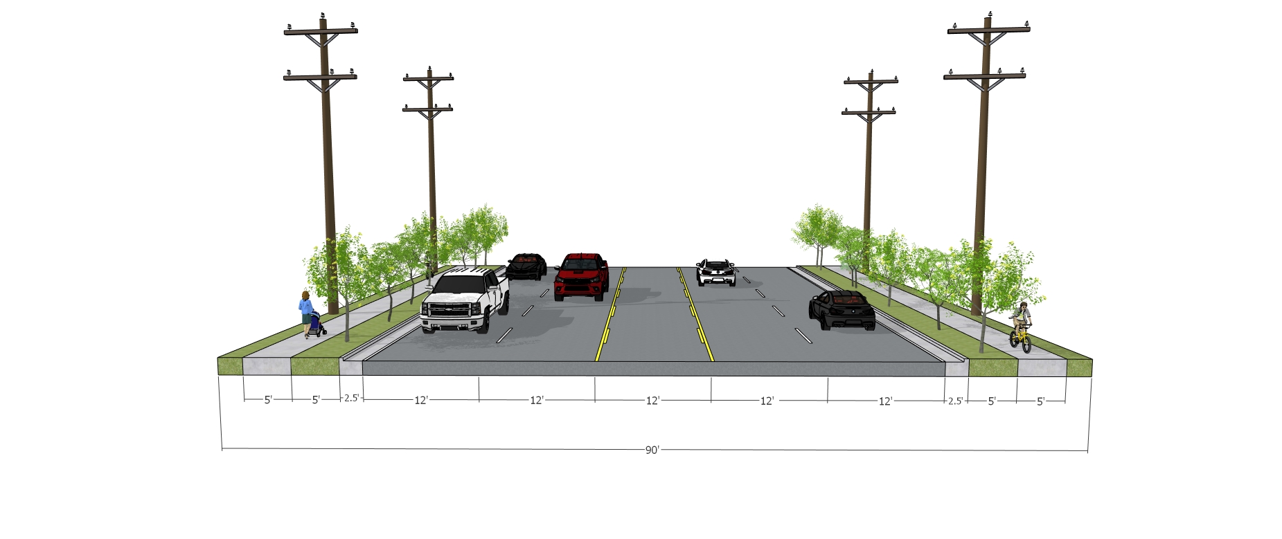 Major Arterials have lane widths ranging from 10'-12' based on speed and volume. For state highways that have no curb and gutter, the paved shoulder should be a minimum of 10'. The recommended speed limit is 30-40 mph, and the maximum daily capacity is 26,800-36,400 vehicles.
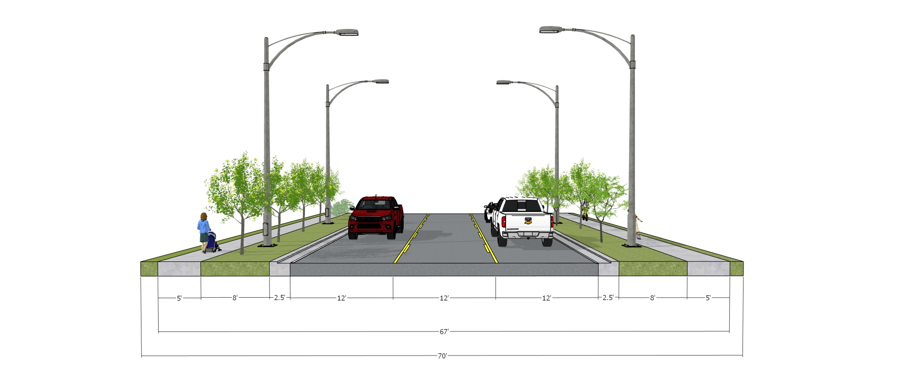 Minor Arterials have lane widths that range from 10'-12'. Two-way left turn lanes should be included where warranted. For state highways, there should be a 6' paved shoulder in addition to the curb and gutter; and clear zone minimums must be met based on speeds. The recommended posted speed limits range from 25-40 mph, and the maximum daily capacity is 14,400-18,600 vehicles.
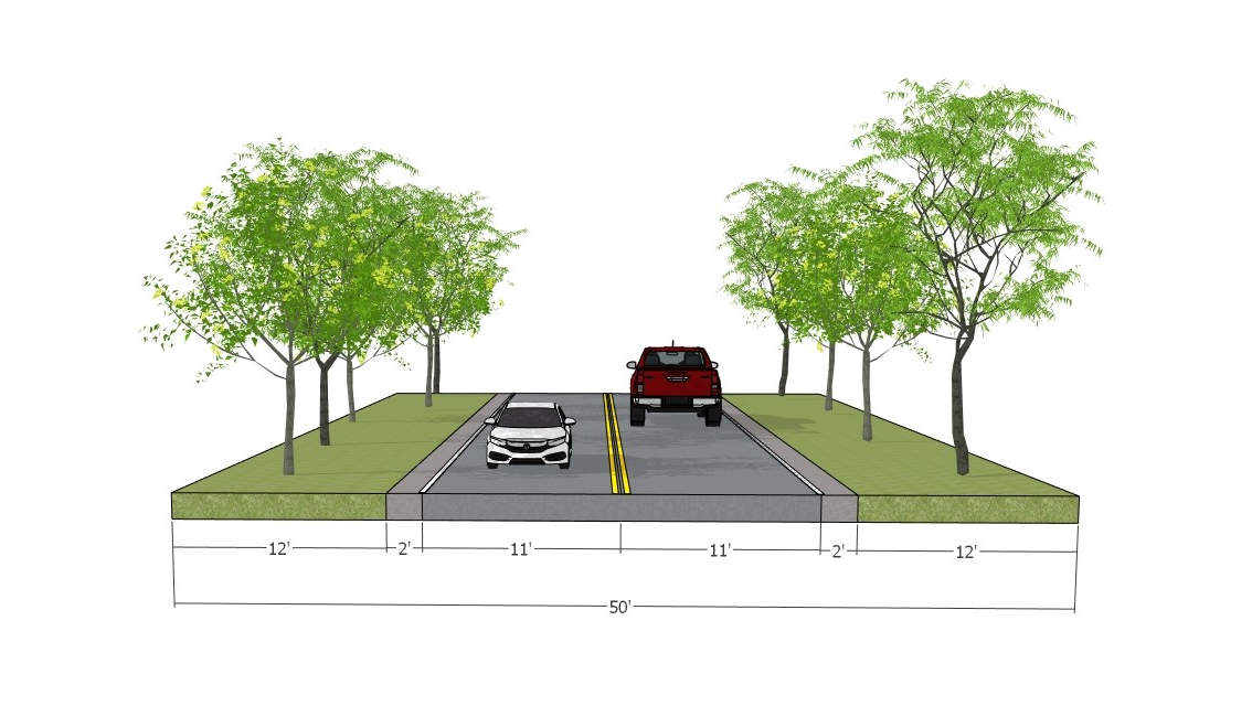
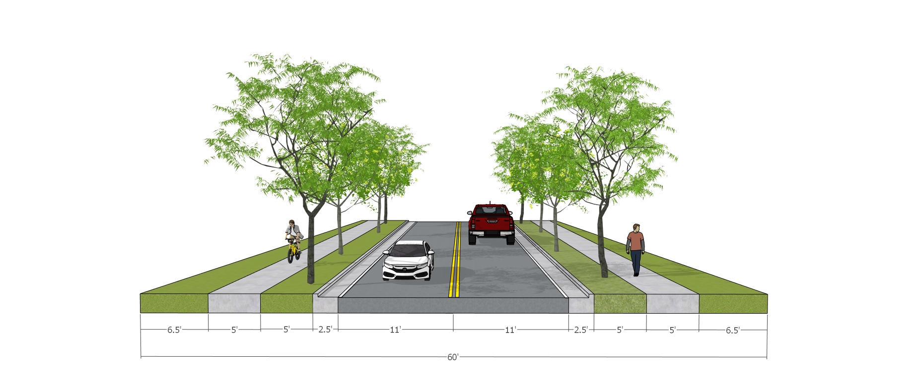 Major Collectors have lane widths that range from 10'-12' based on speed and volume. For state highways, there should be a 6' paved shoulder in addition to the curb and gutter; and clear zone minimums must be met based on speeds. Where needed, excess right-of-way will be needed for bicycle and pedestrian facilities or turn lanes. The recommended posted speed limit ranges from 25-40 mph, and the maximum daily capacity is 9,100-11,600 vehicles.
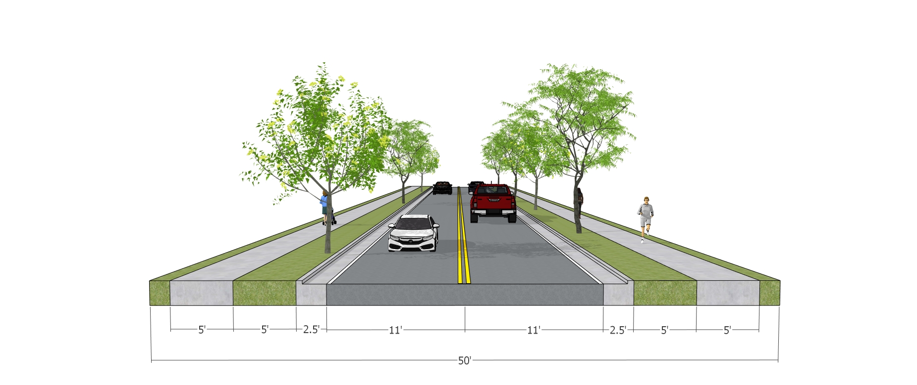
Minor Collectors have lane widths that range from 10'-12' based on speed and volume. For graded shoulders, the width may range from 2'-8' based on speed and volume. Bicycle and pedestrian facilities may be warranted based on presence and proximity of bicycle and pedestrian attractors and generators. Where needed, excess right-of-way will be needed for bicycle and pedestrian facilities or turn lanes. The recommended posted speed limit ranges from 30-45 mph, and the maximum daily capacity is 9,100-11,600 vehicles.
Local streets have lane widths that range from 9'-12' based on speed and volume. For local streets without a curb and gutter, the graded shoulder should be a minimum of 2'. Rural local streets most often will not warrant bicycle and pedestrian facilities. The recommended speed limit is 25 mph, and the maximum daily capacity is up to 9,100 vehicles.


